For a number of years, I have advocated that pre-flight planning should begin up to a week prior to the flight date. Thus, when my wife, Frances, and I scheduled a trip from home in southeast Alabama to Myrtle Beach in mid-February, I began looking at the weather.com weekly planner about seven days ahead of the planned departure of Wednesday the 12th. At first it looked like we were in for a general rain event over much of the southeastern U.S. Then the northern Alabama/Georgia forecasts for Sunday-Monday changed to a “wintry mix.” I began looking at the 36 and 48 hour Progs even though they did not yet cover Wednesday. Even with ice protection installed on the Cirrus, it was clear that some interesting weather was going to factor into the “go/no-go and when” decisions.
And “when” is a fundamental part of what I teach: for the vast majority of our GA flying, the “when” really is negotiable. By Monday morning I had to tell Frances that we needed to think about either flying on Tuesday or Thursday or not going at all. We decided to shoot for Tuesday and began accelerating all of our normal “get ready” activities.
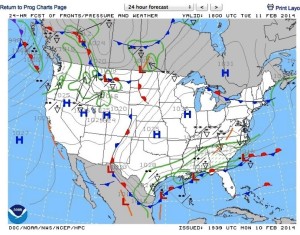
Let’s look at the 24-hour and 48-hour Prog Charts that were available for me on Monday afternoon: valid at Noon Tuesday the 11th, and 6 a.m. Wednesday the 12th, (local times, CST). Visualize Myrtle Beach (CRE) just south of the South Carolina-North Carolina line. The noon Prog at left (24-hour/1800 UTC) showed “Broken” (50 – 100 percent coverage) light rain and rain showers over the whole Headland-Myrtle Beach route with the light to moderate snow dividing line just to the north of Myrtle Beach. Also just to the north of our destination were some symbols we don’t often have to deal with: freezing rain and ice pellets.
It also shows an interesting condition where the light rain slacked off to a “Scattered” condition (30 – 50 percent coverage) but it looked like the freezing rain and ice pellets would extend south to just about Myrtle Beach.
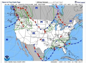
By 6 a.m. Wednesday (48-hour Prog below, 1200 UTC Wed.), the freezing rain and ice pellet condition was forecast to extend over all of northern Georgia and all of South Carolina. Clearly, Wednesday would not be a flying day. But, Tuesday mid-day looked like it was worth an additional look.
Frances likes to do all her planning long range. Cutting 24 hours off of her packing and preparing schedule was not something she was happy about. However, we talked it over and she agreed we should go ahead and take the next steps to be ready for a possible Tuesday noon departure.
Tuesday morning I did my final survey of all the weather information. The forecast freezing level was about 9,000 and the winds were westerly. No ice was forecast below that altitude, so I planned for 7,000. The CRE TAF called for opposite-direction northeast winds, 900 broken, light rain and sleet with freezing rain to start in the early evening - well after our arrival. I filed Charleston (CHS) as our alternate. I figured that if CRE was anywhere near minimums as we went by CHS, we would just stop there and drive up US 17. I have to admit that I was a little nervous that the flight would not be a fun experience for Frances, since she prefers a smooth ride outside of the clouds.
At our IMC Club meeting the previous Saturday I had made a point of the importance of doing everything possible to keep our flying partners happy. But everything I was seeing called for a basically smooth ride, though we may or may not be on top.
The Flight
At departure time, the ceiling at Headland (0J6) was about 900 so I called Cairns Approach on my cell phone prior to taxiing out and got my clearance with a void time. We took off and climbed to 7,000, leveled and set cruise power. The OAT was 50 degrees Fahrenheit and the wind was on the tail at about 30 knots. Soon we were cleared direct to Charleston and all was good: steady 30 knot tailwind, very light turbulence, and almost constant light rain.
The view outside was like being in a bowl of milk; no horizon but bright enough to need sunglasses. The OAT gradually drifted down and by the time we neared Charleston it was down to 41F. About 30 miles west of CHS we were handed off to Beaufort Marine Corps Air Station (NBC) Approach. Since the frequency was quiet, I asked him to give me CRE’s latest METAR. He was happy to do so. CRE 1753Z 020/9G15 5M 9BKN 13OVC +1/-1 3026.
Soooo, the ceiling was well above minimums (250/1 for the LPV 5) but while the OAT at 7,000 was still well above freezing, the surface temp was right at 0 C. I decided to turn on the Cirrus’s ice protection for a minute to get the system primed. Also, I noted that the surface wind was about 180 degrees from what we had at 7,000; I told Frances that we might have a little turbulence as we descended through the sheer.
The Approach
We were turned over to Myrtle Beach Approach and given our first descent, then cleared to cross PLANN at or above 2,100 and cleared for the RNAV 5 Approach. In the descent, all went well. I watched on the PFD as the wind direction shifted from west around to south and then to northeast. I was pleasantly surprised that the ride remained very smooth. However, I did not monitor the OAT.
I leveled at 2,100 and watched for the glideslope needle to come alive. When it centered, we started on down, smooth as could be. We were still in light rain and clouds but could occasionally see the ground through breaks.
As we descended through about 1,500, the windshield suddenly became covered with translucent ice. I immediately turned on the ice protection to max and the windshield defroster to max heat. In less than a minute, the ice began to melt at the bottom center of the windshield and the hole rapidly began to enlarge. By the time we were on short final, it was completely clear.
Landing was a nonevent and we taxied to parking. The next big thing was to get Frances safely inside the terminal in the face of the blowing sleet and rain. With the help of the fine people at North Myrtle Beach Aviation, I got the baggage transferred from the plane to the car and we were soon on our way to several days of relaxation at the beach.
Lessons Learned and Re-learned
I reinforced my opinion that pre-flight planning should begin at least five to seven days prior to a typical GA flight. If we had stuck to our original plan to fly on Wednesday, we would have had to either cancel or incur much higher risk of not completing the flight as planned. See USA Today headline for Wednesday.
I should not have allowed myself to be surprised by the sudden appearance of ice on the windshield. I had become fascinated by watching the wind direction swing, the glideslope capture, and the breaks in the undercast, and so I failed to monitor the OAT. “Clearly,” had I been watching the OAT, I could have anticipated what was to come and preemptively turned on the ice protection system and the defroster. It would have prevented the sudden surprise.
REALLY! Don’t Be Surprised!
- By William Castlen

